 |
Excavations at St. George's Clocktower
|
|
 Two large trenches were opened on the Clocktower site, the first
alongside St George's Street, exposing the remains of St George's
Church, the second against Canterbury Lane, recording the complete
archaeological sequence to natural brickearth. The excavations,
conducted in advance of a major retail development, were funded by Land
Securities.
The Roman
levels
Two large trenches were opened on the Clocktower site, the first
alongside St George's Street, exposing the remains of St George's
Church, the second against Canterbury Lane, recording the complete
archaeological sequence to natural brickearth. The excavations,
conducted in advance of a major retail development, were funded by Land
Securities.
The Roman
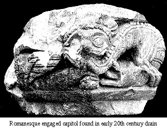
levelsThe earliest archaeological feature found on the site was a ditch of Late Iron Age or early Roman date beneath St George's Church. The ditch was associated with and was sealed by a thick deposit of loam interpreted as agricultural soil which appears to have developed throughout the first and second centuries A.D. Although only a short length of the ditch was identified in the sides of deep cuttings under the church, its shape and size may indicate that it was a field boundary. Previous excavations and observations confirm that this area remained undeveloped until at least the mid second century. Similar agricultural loams have been located on a number of sites together with evidence for cremation burials. A boundary separating the early Roman settlement from open ground to the east may have been established in the mid to late first century when a north-east to south-west aligned street (part of the early grid) was laid out a short way west of the present site. A large clay quarry, which yielded a corpus of late first- to early second-century ceramics, was located against Canterbury Lane. The presence of this and other substantial quarries to the east implies that the agricultural use of the area may have been downgraded to quarrying and disposal of rubbish at this time, a land use consistent with the margins of an expanding urban settlement. By the mid second century a second street, aligned north-west to south-east, had been established at right angles to the first, crossing the northern end of the Canterbury Lane trench. The metalling appears to have been laid merely to give access to the open ground as it was not found during excavations conducted further to the east. Only the south-western edge of the road fell within the present excavation and, rarely for a well-constructed Roman street, there was no side drain, despite clear evidence for multiple remetallings. Whatever its original purpose, this extension to an existing grid preceded the construction of a number of buildings. Fragmentary traces of a timber structure or structures were found against the south-west side of the street in the Canterbury Lane trench and a courtyard of flints, broken bricks and tile was recorded in the sides and bases of deep cuttings under St George's Church. Although unconnected these discoveries indicate some form of urban expansion in the south-east quarter of the town from the mid second century. The southern part of the Canterbury Lane trench appears to have remained undeveloped. The courtyard under St George's Church was capped by a deposit of loam perhaps indicating a brief period of abandonment. Overall this early phase of development was probably of short duration and of an insubstantial nature. A major phase of redevelopment appears to have taken place in the mid third century. At this time the area of the Canterbury Lane trench received the first of a number of major courtyard metallings associated with areas of poured mortar and debris consistent with episodes of rebuilding or the repair of adjacent buildings over a considerable period. The courtyard metallings were carried over the foundations of the earlier timber buildings to the north-east to merge with successive metallings for the adjacent street. No apparent division between the courtyard and the street existed, and there seemed to be direct access from one to the other. At the point of junction between the metallings however substantial occupation deposits were evident. Finds from these layers included a speculum bronze mirror and the pipeclay horse featured on the cover of last year's report. Associated with this courtyard, but found during preparatory earthworks for the new development after excavation had ceased, was a rectangular masonry building constructed in the mid third century measuring 9.63 m. x 7.82 m. It was exceptionally well-preserved with walls standing to a height of approximately 1 m. overlying relatively shallow gravel-filled foundations. Walls of coursed flints, and double brick string courses were bonded at the internal corners with tile. Although much of the building interior had been removed by later pits, sufficient evidence survived to suggest that it had been provided with a raised timber floor. A number of other wall footings located at this time may also have formed part of this structure or an adjacent building. The extensive metallings excavated within the Canterbury Lane trench were not evident under St George's Church. The rectangular structure located between the trenches north of the existing Clocktower appeared to mark the end of the courtyard and some form of boundary, perhaps a wall, may have existed between the two excavated areas. Although some slight evidence for later building activity was recorded under the church this appeared to form part of a separate structure or structures south-east of the postulated boundary. The rectangular building with walls and courtyard may have been associated with a substantial Roman building with apsidal east end excavated just south-east of Canterbury Lane in 1949. This building, now under St George's Street, with its south-east apsidal end adjacent to and just south of the Clocktower may have formed a principal range built in c. A.D. 250. The north-western end of this structure fronted onto the north-east to south-west aligned street. A contemporary wall extending north-east from the building parallel with the street may have been a boundary enclosing the north-west side of the courtyard metallings uncovered in the Canterbury Lane trench. The rectangular building of unknown function may have formed part of the same complex and defined a south-eastern boundary to the enclosure. Together the recently excavated building and courtyard may have been part of a prestigous town-house located towards the edge of the town. The courtyard and rectangular building appeared to have gone out of use during the fourth century. The apsidal-ended range was considered to have been ruinous by this time. The Post-Roman LevelsOverlying the latest Roman levels in both trenches was a thick deposit of `dark earth' indicating a cessation of significant occupation in the area. The loams yielded a large quantity of abraded residual Roman ceramics. In the Canterbury Lane trench, the loam deposits were sealed by a loose-textured metalling interpreted as a courtyard. The metalling which predated the cutting of a number of later tenth-century pits may be associated with a late ninth century to early tenth-century cobbled surface discovered by earlier excavations north and east of the present trench. Traces of a possible building flanked the eastern side of the present metalling, defined by a small number of post-holes and deposits of burnt daub. Residual finds from nearby later features and deposits included sherds of ninth- to late tenth-century date. The line of St George's Street, the Parade and High Street was probably formed as a principal thoroughfare joining West Gate and a newly built gate at Newingate by the mid tenth century. Canterbury Lane (referred to as Semeres Lane in early thirteenth-century rentals) was probably laid out some time after this. A number of pits of the late tenth and eleventh centuries probably represent an occupation of the site after the new road had been established. The pits were associated with garden loams which sealed the earlier courtyard.
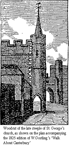
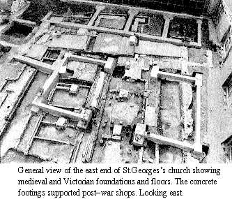
Only fragmentary traces of the primary church survived disturbance by later foundations and graves. There was however, sufficient evidence to provide a tentative plan of the arrangement. Two phases of construction were identified, defined by the character of the foundations and the materials employed in the tootings. The primary two-cell structure of nave and chancel with apsidal east end (Phase I) was extended to the north by the addit on of an aisle extending for the full length of the nave (Phase II). A precise dating of the primary church was difficult to establish on the basis of finds obtained during the excavation. Detailed analysis of the excavation records has yet to take place but at the present time a pre conquest date for the church seems unlikely and an immediate post conquest date is favoured. The construction of a north aisle was perhaps a separate stage of the sarne building campaign or more likely an addition soon after the primary church had been built. The rapidity of successive enlargements of St George's Church from the late eleventh century up to the mid fourteenth century appears to be a direct response to a rapidly expanding population within the urban nucleus of Canterbury. A major reconstruction of the chancel (Phase III) probably took place early in the twelfth century. The previous chancel was demolished to a point west of the chancel arch and replaced by a wide and deep rammed gravel-filled foundation carrying what has been tentatively identified as an east end of three intersecting segments of circles. Only the southern lobe survived above foundation level, but the curving foundations of the eastern lobe approximately mirrored that to the south indicating this curious but symmetrical arrangement. Identical and contemporary foundations for an extension of the south wall east of the original nave and an extended north aisle also formed part of this re-arrangement. This interpretation is likely to cause much debate since although `tri-conch' apses are not unknown in the late Roman period on the continent or in the Near East, they are unknown in this country. A new west wall of a slightly lengthened nave with a new west door was also constructed perhaps in the mid twelfth century (Phase IIIa). Parts of the original Caen stone doorway and a pilaster buttress to the north as well as some diagnostic facework still survives above ground on the western side of St George's tower. None of this area could however be excavated so the foundations are unknown. The unusual and no doubt controversial arrangement interpreted as Phase III appears to have had a fairly short life. The eastern apse was demolished and the remaining southern and perhaps northern apses were incorporated into a more conventional rectangular structure (Phase IV), probably in the late twelfth or very early in the thirteenth century. A major re-arrangement of the east end of the church then occurred in the mid thirteenth century (Phase V). This building campaign saw a lengthening of the square chancel and an extension of the north aisle to form a north-east chapel (Lady Chapel). It was perhaps during this phase of enlargement that the northern apse of the Phase III chancel was taken down. A narrow shallow north-south foundation identified at the east end of the new Lady Chapel may have been for a raised altar platform or step. Later in the thirteenth century the northern aisle was widened (Phase VI) with the eastern end of the aisle carried on an exceptionally wide and deep sub foundation of laminated and rammed deposits of chalk and gravel carrying a mortared flint foundation. More substantial pier bases for a new arcade also formed part of this new arrangement, though the first arcade must have dated from the twelfth century. Perhaps at about this time a tower was added to the north side of the church (Phase VII) with access to the tower from the Lady Chapel. The foundation of the south-western corner of the tower was cut into the north-east foundation of the aisle, indicating that it was sequentially later than the aisle foundations. However, the size and depth of the aisle foundation at this point, and similarities in the materials employed in the footings of both tower and aisle, tentatively suggest that the enlargement of the north aisle and the construction of the tower may have formed part of a single building campaign, or that only a short period separated both episodes of construction. The foundation for the south-eastern corner of the tower was cut through the line of the north wall of the chapel, perhaps indicating that the chapel wall had been taken down to enable tower construction and widening of the chapel beyond the east wall of the tower. Foundations for this extension were located, together with fragmentary traces of a contemporary buttress extending north from the north-east corner of the new chapel. A massive pier foundation on the south side of the chapel may have been formed at this time to carry new arcading for chancel and chapel. The south wall of the church must have been completely rebuilt above ground in the early fourteenth century (Phase VIII), with additional foundations added to the external face of the wall effectively burying the remains of the Phase III south `lobe' beneath the new work. Pre-war photographs show that all the windows on the south side were built in an early fourteenth-century style with ogee heads and square hood-moulds. Associated with the rebuilding of the south wall were the foundations of a small south-east vestry. During the later fourteenth or early fifteenth century a final phase of work at the church took place (Phase IX). This involved the construction of the present west tower (now the 'Clocktower'). The tower was built inside the nave at its west-end on four new piers with plinths. The northern tower was probably demolished at this time and a wide but relatively shallow foundation was constructed to carry new work closing the breach in the chapel wall. The new western tower, with crenellated parapet, two-light perpendicular windows and a south-east external stair turret with spire, incorporated the fabric of the extant (Phase IIIa) west wall and doorway. During pavement improvements in 1788 the vestry was demolished and the turret pierced for a pedestrian walk. The blocked doorway into the vestry as well as a fine early fourteenth-century sedelia (with ogee heads) just to the east, survived on the north side of the vestry wall until the 1950s. The turret was demolished in 1794 after it became unstable. In 1871 the parishes of St Mary Magdalen and St George were united and a decision was taken to enlarge St George's church to accommodate both congregations. This work, put in hand in 1872, saw the construction of a new north aisle and a small extended chancel east of the earlier north-east chapel (Lady Chapel). Two new arcades were constructed (in part using the old `Transitional Norman' columns and arches from St Mary Magdalen) and the old east window of the Lady Chapel was moved to the west end of the new north aisle. The substantial brick foundations for the 1872 work, together with a number of later insertions, including a boiler house, were recorded during the excavation. Early floors were removed to accommodate timber sprung floors, tiled pavements and a central heating system. Ledger slabs were relaid in new positions and overall few traces of the original internal floors and fitting survived late nineteenth-century re-organisation. St George's Church was gutted by fire during an air-raid on 1st June 1942 and levelled prior to redevelopment in 1955. Post-war reconstruction saw a widening of Canterbury Lane and the covering of a long-lived and changing pattern of domestic properties by modern road materials. Only the rear of the Canterbury Lane properties fell within the excavation area and the sequence here from the twelfth century onwards consisted of garden loams cut by a substantial number of rubbish and cess pits. A small number of fragmentary post-medieval and modern timber-framed and brick-built outbuildings were also recorded here. A large number of burials were located within the body of the church. Although a number of fifteenth-century wills and other documents exist indicating burial at St George's Church detailed work on these has yet to take place. Two stone-lined cists for coffined burials were recorded, both probably of the fifteenth century. One was cut into the nave south wall and part of the second was located centrally in the nave. The second of these burials may have removed an earlier stone-lined cist. The remaining burial vaults were all of brick construction and most burials appeared to be of later medieval or post-medieval date.
To the north and east of the church was an extensive cemetery. Burials were also located under the vestry to the south-east. A north-south aligned flint and chalk built wall, found overlying the foundations of the former northern tower, marked the western boundary of the cemetery, perhaps established in the post-Reformation period. The wall is shown on numerous maps of Canterbury dating from the mid eighteenth century onwards. To the west of this wall were the foundations and floors of the timber-framed rectory of St George's church built in c 1700. A passage way ran down the west side of the church with the White Lion inn on its west side, connecting the rectory with St George's Street. A small courtyard containing a large brick-lined well separated the rectory and the cemetery. The cemetery area received only minimal excavation with trenches cut on the site of proposed large and deep foundations for the new building. Burials located during the cutting of these pits were fully recorded. All burials appeared to be of post-medieval date, this perhaps confirmed by early (pre Reformation) wills which only mention burial within the church. The discovery of an industrial feature, perhaps associated with bell-casting, located in the cemetery area, but predating all burials, also suggests a later date for the cemetery.
|
 Beneath St George's Church the latest Roman horizon and subsequent
`dark earth' deposits were sealed by a well-defined laminated occupation
horizon dated by ceramics to the mid to late eleventh century. Although
no part of the horizon was excavated in plan it appeared to comprise
occupation floors of beaten burnt earth and burnt clay capped by
deposits of ash and carbon. The horizon may represent a group of flimsy
timber structures established against the north side of early St
George's Street. No structural details (post-holes, beam-slots or
masonry foundations) were observed and the nature of the occupation
horizon remains enigmatic. It is clear however, that the occupation
sequence was terminated abruptly perhaps by fire and the site cleared
late in the eleventh century to make way for the construction of the
first church.
Beneath St George's Church the latest Roman horizon and subsequent
`dark earth' deposits were sealed by a well-defined laminated occupation
horizon dated by ceramics to the mid to late eleventh century. Although
no part of the horizon was excavated in plan it appeared to comprise
occupation floors of beaten burnt earth and burnt clay capped by
deposits of ash and carbon. The horizon may represent a group of flimsy
timber structures established against the north side of early St
George's Street. No structural details (post-holes, beam-slots or
masonry foundations) were observed and the nature of the occupation
horizon remains enigmatic. It is clear however, that the occupation
sequence was terminated abruptly perhaps by fire and the site cleared
late in the eleventh century to make way for the construction of the
first church.
Peter Collinson Last change: 18th November 2018