 |
All Saint's Church
|
|
|
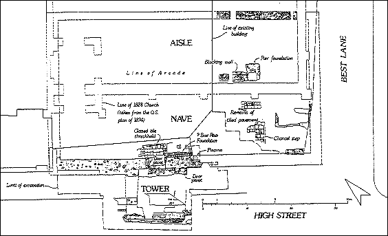
During Autumn 1986 the City Council and British Telecom jointly funded an excavation against the intersection of High Street and Best Lane. This work, in advance of repaving the western end of High Street and St Peter's Street, was undertaken to expose the remains of medieval All Saints Church, demolished in 1828, and its Victorian successor pulled down in 1937. It is intended that the principal walls and internal features of the early church will be marked out in the new pavement. The excavation was largely staffed by members of our M.S.C. Community Programme team, under the supervision of Alan Ward. Our excavation strategy was to remove all modern overburden (post 1828) and recover as complete a plan as possible of both churches without disturbing the medieval levels to any great extent. The medieval church. extant by c 1200 (see W. Urry, Canterbury Under the Angevin Kings (1967), 210), with nave, chancel and north aisle, had a southern porch with tower over. The east end of the church constricted Best Lane and the southern porch with tower encroached onto the High Street. The Victorian church, with nave, chancel, south aisle and tower at the west end of the aisle, was set back from the High Street frontage. Only the east end of both churches and the south side of the medieval church were located in the excavation. The remaining portions of both structures lie under the former Gas Showroom. The churchyard still exists as a small garden set back from Best Lane to the rear of the Gas Showroom. (The Gas Showroom has now gone, and the shop is Whittards selling coffee). Although short lengths and fragments of the north, east and west walls of the medieval church and the foundations of the south tower were exposed, the most impressive remnant proved to be the south wall. The wall, flint-built with plaster adhering to the internal face, survived to a height of 1 m. above the latest internal floor. The south door was particularly well preserved, with jambs of small Caen blockwork. An iron pivot for a single leaf door survived in the east jamb. A glazed tile threshold, just inside the door, overlay a sequence of beaten earth, mortar and crushed chalk floors that appeared to extend throughout the nave area. The fragmentary traces of a tiled floor survived in the chancel, together with traces of the chancel step and altar base. The remains of a hexagonal piscina bowl survived set in the south wall, east of the door. The substantial foundations of the tower were revealed during excavations under the High Street. The tower, of contemporary build with the church south wall, had doors to the south and east. An iron door pivot survived on the northern jamb of the eastern door. Traces of a tiled floor survived within the body of the tower. Thomas Langdon's map of the Blackfriars area in 1595 shows a small building attached to the exterior of the church west of the tower, together with a courtyard wall extending from the tower to the intersection with Best Lane. Traces of a clay floor located during trenching west of the tower may have been associated with the building shown on Langdon's Map. A single course of unmortared bricks located against the south-east corner of the tower may have been remnants of the courtyard wall. The tower was demolished in 1769, during a bridge and road widening scheme. A brick threshold incorporating at least two steps with timber treads, was built between the jambs of the church south door at this time. A brick foundation for a boxed pew was also constructed at this time just east of the south door against the south wall. Flint and gravel metallings for a narrow east/west lane (also shown on Langdon's map) were located immediately north of the medieval church. The lane probably gave access to the mill and river; north of the lane were the remnants of the churchyard wall. A further wall fragment located in the extreme north-east corner of the excavation was part of the contemporary churchyard wall flanking Best Lane. This is known to have been interrupted by a gate some way north of the church. Three graves found cutting the lane metallings and later sealed by the Victorian church foundations indicated that the lane had gone out of use well before 1828. The external walls of the Victorian church were built from re-used materials and external buttresses of brick were incorporated in the load-bearing walls. A number of internal walls constructed from re-used materials supported internal sprung floors and housed burial vaults. The Victorian church was finally demolished in 1937. Our thanks are extended to Canterbury City Council and British Telecom for financing the excavation, to Dennis Button and David Latham of the City Council's Engineering Section, for their help and support and finally to the hardworking team who under Alan Ward's supervision, brought this interesting project to completion. 
This map somewhat too small to make a sensible scan from, sorry.
|
Peter Collinson Last change: 18th November 2018